


la chapelle

Claude Luchetta
User
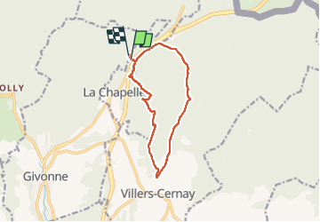

Length
10.4 km

Max alt
410 m

Uphill gradient
243 m
Km-Effort
13.6 km

Min alt
238 m

Downhill gradient
238 m
Boucle
Yes
Creation date :
2022-11-15 08:18:41.572
Updated on :
2022-11-15 11:11:01.871
2h51
Difficulty : Easy

FREE GPS app for hiking
 SityTrail
IGN / Geographical institutes
SityTrail Plus
The world is yours!
About
Trail Walking of 10.4 km to be discovered at Grand Est, Ardennes, La Chapelle. This trail is proposed by Claude Luchetta.
Positioning
Country:
France
Region :
Grand Est
Department/Province :
Ardennes
Municipality :
La Chapelle
Location:
Unknown
Start:(Dec)
Start:(UTM)
645660 ; 5512852 (31U) N.
Comments